


The Day the Sky Rolled In, I Missed One of Portugal’s Rarest Cloud Events
While I sweated through a heatwave, my mom watched a giant roll cloud sweep across Portugal’s northern coast


Every year, my mother enjoys going to Póvoa de Varzim for St. Peter’s celebrations, and this time she got more than she bargained for.
A strange day at the coast
Mom planned to spend the day at the beach and watch the St. Peter’s procession at the waterfront promenade, Póvoa’s beautiful Marginal, as we call it.
She left early in the morning and was among the first to arrive at Praia dos Beijinhos in Póvoa de Varzim for what she expected to be a quiet day by the sea.
Less than 20 miles away, I was back home trying to cool off from a sweltering heatwave, with temperatures nearing 40 °C.
Here in the Portuguese northern coastal region (the litoral), you can easily go from 25 °C by the sea in Porto to +35 °C where I live (a less than 30-minute trip by car).
When the sky rolled in
Sunday was a weird day in the Portuguese litoral. While we had clear skies in Santo Tirso, people at the beach in Póvoa de Varzim were complaining about the weather.
Around 3 pm, Mom called me to say it was chilly and raining at the beach. I was amazed because it was blazing hot back home.
While I was on the phone with her, I checked our national forecast, and there wasn’t any report of rain anywhere in Portugal.
Nobody saw this coming, not even meteorologists.
Mom tells me how everyone had to take shelter under the guarda-sóis (beach umbrellas) and the traditional white and blue striped barracas (beach tents).
The signs were there. But no one noticed. Nature was plotting an even bigger surprise for everyone at the end of the day. All the ideal conditions for a strange meteorological event were brewing at sea without anyone noticing it.

Afternoon Glory
Late in the afternoon, my mother noticed a commotion. She looked around and noticed people pointing to the sea.
Something is wrong.
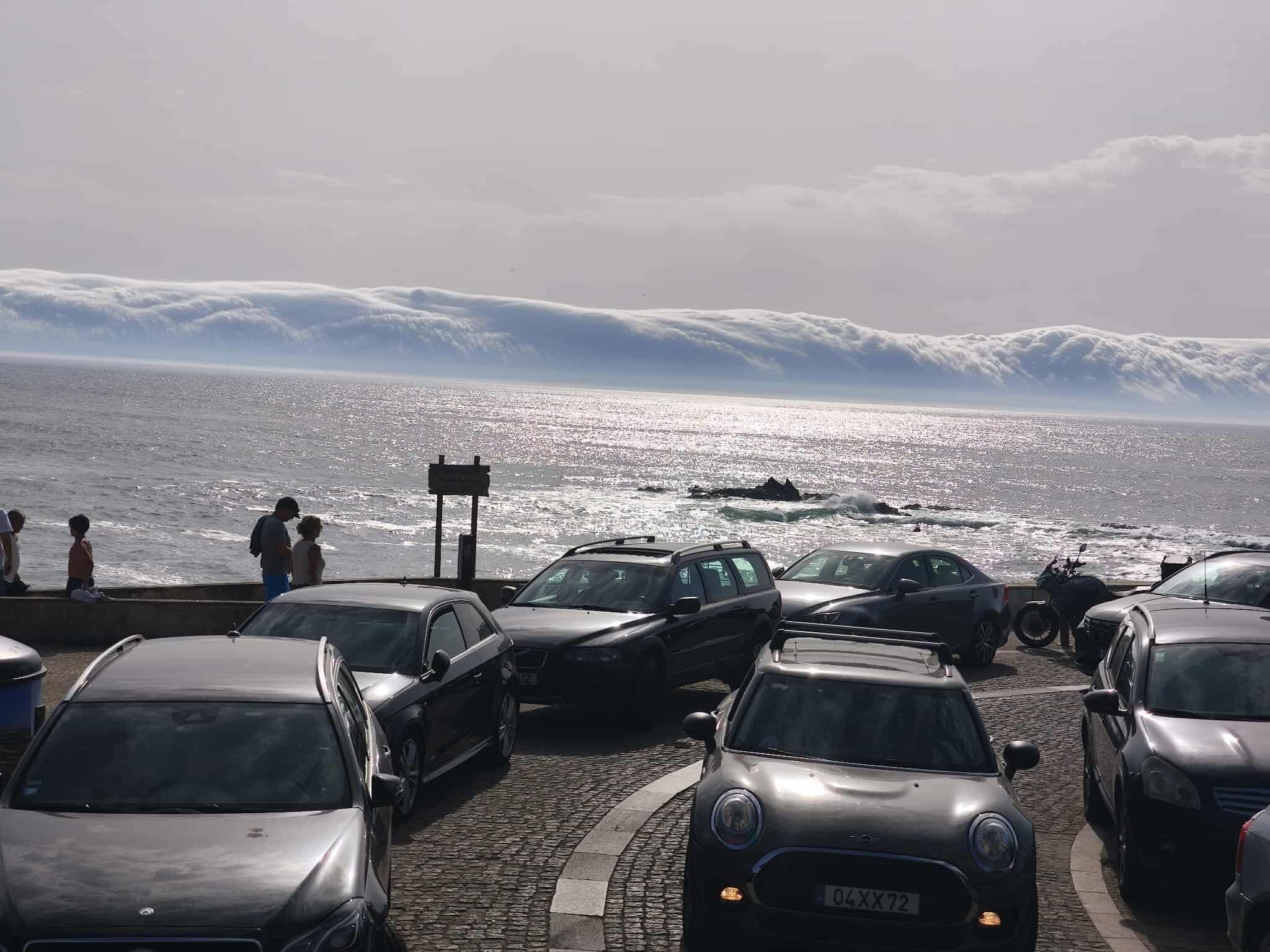
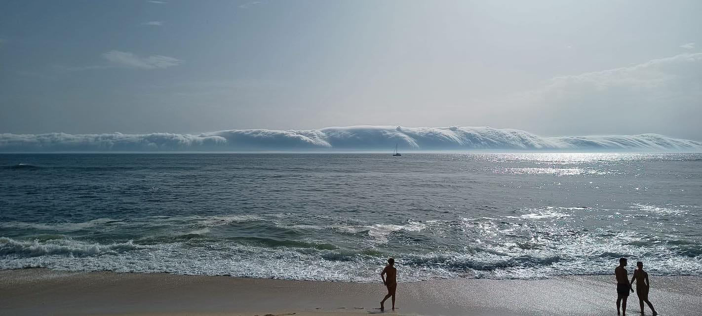
That’s when she spots it. The sky seems to be rolling in, as an ominous cloud, resembling a giant, ethereal serpent, slithers over the waves.
Then, she calls me again.
I answer it, and mom starts narrating what is happening while she picks up her things and decides she has had enough of strange events for a day.
I hear her words and try to picture the gargantuan roll cloud stretching frighteningly across the line of the horizon like a fluffy mountain range.
Curiously, the roll cloud appeared just after the end of the procession honoring St. Peter, the patron saint of Poveiros fishermen, whom Portuguese Catholics believe has control over the weather.
With that in mind, it’s easier to understand why some beachgoers felt afraid.
Who could blame them?
Most of us would be scared looking at such an ominous sky and seeing a particularly frightening cloud formation.
I think they were lucky to witness such a rare event.
My mom is still talking to me on the phone. Telling me how people are mesmerized by one of nature’s great wonders. How they just stood there, looking at it, astonished.
I imagine people grabbing their phones to capture the moment. I was right, and soon enough, my Instagram and TikTok were overrun by a tsunami of roll cloud pictures and videos.


In the meantime, I was also checking my phone to figure out what was going on. That’s how I learned roll clouds belong to the arcus category, a cloud formation which stands out from the other clouds for its cylindrical appearance.
Looking at the pictures, I’m fascinated by the beauty of it. I see why people living in Northern Australia have a distinctive name for this unique cloud formation.
They call it Morning Glory.
For me, these majestic cylinders hovering a few hundred meters from the sea look like capsized tornadoes on their side rolling just above the horizon at great speed, even if for a few moments they just seem to be hovering there, almost frozen in time.
The science behind the cloud
Roll clouds are tub-shaped, low-altitude clouds that “roll” across the sky, as if they had a horizontal, invisible axis.
You don’t see them often. I think the last time we had a similar cloud event in Portugal was more than 25 years ago.
If I recall it correctly, this happened back in 1999, in the Algarve, and it caused real panic.
Back then, people still had in mind what had happened in Indonesia six years earlier, in 1992, when a tsunami claimed many lives.
This was probably why many believed they were seeing a tidal wave. Reports from the time note how people thought they were seeing a “giant wave on the horizon” and fled the beaches in a panic.
So, the southern part of the Gulf of Carpentaria in Northern Australia is, in fact, the only known location where roll clouds can be observed regularly due to the configuration of land and sea in the area.
The science behind it says they form in the presence of cold fronts and the absence of thunderstorms. It results from the difference in temperature between the land surface and the sea.
When vertical wind shear combines with the forward movement of the wind, it can create a rolling, helical motion in the atmosphere. Which leads to long, tube-like vortices that spin in opposite directions. These rolls align with the direction of the wind and contain alternating zones of rising and sinking air.
In the figure below, you can see a simplified diagram of how these roll vortices form in the lower part of the atmosphere.

This explains how, on a windy day of extreme heat, we had a “perfect storm” scenario, which no one can predict.
The phenomenon occurring in the late afternoon may also be linked to the Nortada, a cold wind that blows along these shores in the late afternoon.
A study published in the Journal of Climate notes how “understanding how marine low clouds and their radiative effects respond to changing meteorological conditions is crucial to constrain low-cloud feedbacks to greenhouse warming and internal climate variability.”
What this cloud event tells us about the future
My mother could have stayed there at the beach and watched the event unfold for a bit longer, but she probably did the right thing by leaving.
I think those beachgoers were lucky to witness such a rare event, which is, in fact, perfectly harmless, even if, when the strong winds hit the shore, things can get a bit messy.
As mentioned in a study about the poetics of meteorology, “Clouds give (often temporary) form to the inexpressible, to the unsayable, to the wonder to be found in beauty.”
Indeed, clouds are “hollow vessels” that can transform into “anything they want.”
So, while on the phone with my mom, the poet in me felt a bit jealous. I would have loved to be there watching such a massive roll cloud unfold.
Hamlet was right, clouds are indeed tricky things. “In their fertile evanescence, they are both full and empty, many and none. They are anything we can imagine, pregnant with possibility, and nothing at all, hollow and shifting. They have shape, but are shapeless. They are material, but of vaporous concoction. They are bodies without surface, forms without line. They are fleeting, sinuous, and transient.” (Peters, J. N., Piechocki, K. N., 2021)
That’s life these days, as volatile, uncertain, complex, and ambiguous as a cloud. You never know what can happen. With global warming and climate change, these natural events will become more common than they were supposed to be.
So this roll cloud apparition didn’t surprise me, knowing Europe is currently the fastest-warming continent in the world. Last Sunday, Portugal reached 46.6ºC, the highest ever temperature recorded in June.
Global warming is real, there’s no denying it. I feel it every day. So I doubt we’ll have to wait long for another rare cloud event. Maybe next time, I’ll be there to see it.
Rui Alves is a language teacher, published author, international book judge, and publisher. He runs Alchemy Publications and serves as editor-in-chief for Engage on Substack, Life Unscripted, Musicverse, Writelicious, The Academic, Portugal Calling, Engage on Medium, Rock n’ Heavy, Beloved, Zenite, Poetaph, Grind, and Babel.
Thank you for reading. A little support goes a long way! If you’d like to help me keep creating, you can do so at my Ko-fi page or consider becoming a paid subscriber here on Substack.

References
Liu, A. Q., G. W. K. Moore, K. Tsuboki, and I. A. Renfrew (2004). “A high-resolution simulation of convective roll clouds during a cold-air outbreak,” Geophys. Res. Lett., 31, L03101, doi:10.1029/2003GL018530.
Peters, J. N., Piechocki, K. N. (2021). “Early modern clouds and the poetics of meteorology: An introduction.” Romance Quarterly, 68(2), 65–78. https://doi.org/10.1080/08831157.2021.1900690
Quan W., Chanh K. (2019). “Dynamics of transverse cloud rolls in the boundary layer with the Poiseuille shear flow.” Physics of Fluids; 31 (9): 096601. https://doi.org/10.1063/1.5109523
Scott, R. C., T. A. Myers, J. R. Norris, M. D. Zelinka, S. A. Klein, M. Sun, and D. R. Doelling. (2020)- “Observed Sensitivity of Low-Cloud Radiative Effects to Meteorological Perturbations over the Global Oceans.” J. Climate, 33, 7717–7734, https://doi.org/10.1175/JCLI-D-19-1028.1.
Swathi, B., Sathiyamoorthy, V. (2025). “Unique roll clouds along the flow path of the Indian summer monsoon low-level jet over the Arabian Sea.” Sci Rep 15, 12700 (2025). https://doi.org/10.1038/s41598-025-97849-9
Ouazzani, Z. et al. (2014). “The Morning Glory: Flow visualization by Mother Nature.” Physics of Fluids 1, 26 (9): 091110. https://doi.org/10.1063/1.4894075
A fascinating mixture of nature and science Rui - thanks for sharing this. I bet you were sorry to miss it but the photos are great. It does look very similar to a tsunami! Take care and have a great day. 😀
What an amazing post! The photos are phenomenal. Thank you for sharing this very rare experience.